Welcome to the Institute of Spatial Data Science.
Spatial Data Science is becoming the new frontier for data analytics, modelling and visualization
It can be very broadly defined as the integration of geographical Information System with Statistics and data
mining.
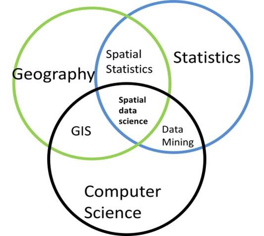 In terms of the Drew Conway Venn diagram below, one could think of the intersection
of geography and statistics as spatial statistics, the intersection of Geography and
Computer Science as Geographic Information System, and the intersection of Statistics
and Computes Science as Data Mining. The intersection of the three disciplines,
Geography, Statistics and Computer Science is Spatial Data Science.
In terms of the Drew Conway Venn diagram below, one could think of the intersection
of geography and statistics as spatial statistics, the intersection of Geography and
Computer Science as Geographic Information System, and the intersection of Statistics
and Computes Science as Data Mining. The intersection of the three disciplines,
Geography, Statistics and Computer Science is Spatial Data Science.
Spatial data science can be applied to monitoring and evaluation, crime monitoring, traffic accident monitoring, poverty and unemployment, health and disease monitoring, correcting the imbalances of the Apartheid spatial planning. It allows analysts to leverage spatial and geographic data in their planning decision making and monitoring across many industries, government and municipalities.
NSAS requested SAS and ESRI to assist to predict a Regression line to assist in the search to recover debri form the ill-fated Columbia space shuttle. The search area was 300km by 60 km and most of the debri recovered was within the regression line and its confidence limits.
This was one of the first applications of Spatial data Science combining geography (GIS ) and statistical regression.
The Institute for Spatial Data Science has launched the Journal of Spatial Data Science which is an completely free, open access, peer reviewed, electronic journal to promote applied research in Spatial Data Science Its main aim is to promote the use of techniques in spatial data science. The journal will be published twice a year, in September and March. The journal is free to readers and authors. Papers will be uploaded in pdf format and readers are free to download the papers
Workshops and Training courses will be available shortly.